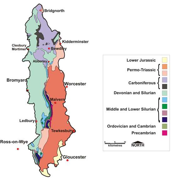
The Geopark is comprised of some 1250 square kilometres of world class geology. It contains rock formations of outstanding geological interest, which span over 700 million years to include some of the oldest the oldest rocks in England.
The rocks tell a fascinating story of continental collision, shallow tropical seas, hot deserts, tropical swamps, coastal lagoons, vast ice sheets and polar deserts. These changes in ancient depositional environments and the associated rock types have produced the diverse landscapes that can be seen in the Geopark today.
The oldest rocks in the Geopark are found in the Malvern Hills. These igneous rocks, formed deep within the Earth’s crust from molten material, belong to the Precambrian period and are aged around 700 million years old.
The rocks of the Abberley Hills were formed during the Silurian period and are aged around 440 million years old. During this period of time, the area was covered by shallow tropical seas teaming with life, providing favourable conditions for the formation of coral reefs.
The Wyre Forest Coalfield lies towards the north of the Abberley Hills. The coal seams were formed during the Carboniferous period (320 million years ago) when the area was covered in dense tropical swamps. Great rivers bought sand and silt from surrounding mountains into the lowlands, forming sandstones which have been used as building stones.
At the beginning of the Permian period (299 million years ago), this area formed part of a shimmering, landlocked desert and many of the red sandstones exposed in the Bewdley, Kidderminster and Bridgnorth area, represent fossilised sand dunes or alluvial fans formed by the transportation of debris by flash floods.
The rocks located at the southern boundary of the Geopark represent the change that occurred towards the end of Triassic period (200 million years ago) from arid, continental conditions to marine deposition within shallow seas that covered most of Europe during the Jurassic period.
Finally, during the quaternary Period, ice age conditions prevailed and have left behind a legacy of river terrace deposits, beautiful river valleys and influenced the present day course of the rivers Severn, Stour, Teme, Rea, Frome and Leadon that run through the Geopark.