What are RIGS/LGS?
RIGS are Regionally Important geological/Geomorphological Sites. They are know in some counties (including Herefordshire and Worcestershire) as Local Geological Sites. They are sites that have been identified by local geoconservation groups as
being of regional importance and then notified to the local authority planning
departments as sites in need of protection from future development.
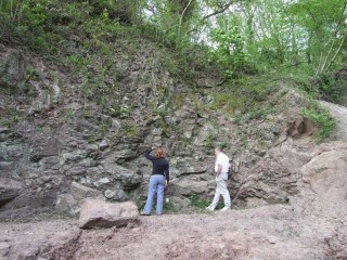
Woodbury Quarry, Worcestershire.
The concept of RIGS was first initiated by the Nature Conservancy Councils (NCC) publication Earth Science Conservation in Great Britain – A Strategy (1990). RIGS sites started life as SSSIs denotified after the Geological Conservation Review (1977-1990). The statutory agencies wished to secure their conservation in another form. RIGS sites are those which, whilst not benefiting from national statutory protection, are nevertheless regionally or locally representative sites where '.... consideration of their importance becomes integral to the planning process' according to the Earth Science Conservation Strategy (ESCS).
How are RIGS/LGS chosen?
A potential site is surveyed and assessed against a national set of qualifying
criteria. These are:
- Educational value for fieldwork in primary and secondary schools, at undergraduate level and in adult education courses
- Scientific value for study by both professional and amateur Earth scientists. Such sites demonstrate, alone or as part of a network, the geology or geomorphology of an area.
- Historical significance in terms of important advances in Earth science knowledge.
- Aesthetic qualities in the landscape, particularly in relation to promoting public awareness and appreciation of Earth sciences.
When a site is chosen for designation, detailed records are made of it and then the information is passed on to the local authority planning departments. They then add it to a special “alert” map to ensure it is “flagged” up as requiring special protection. At the same time the records are also stored on the Trust's Geological Records Database.
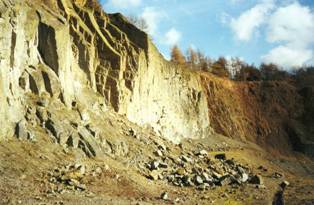
Huntley Quarry, Gloucestershire
RIGS/LGS in the Geopark.
The Abberley and Malvern Hills Geopark is an area of outstanding geology and
geomorphology.
RIGS/LGS can vary in size from a small exposed bank in an old quarry to large sections of the Malvern Hills. Currently, there are 180 designated RIGS records for the Geopark held by the Geology Trust. These sites give important clues and/or evidence about the history of the geology and landscape of the area.
Other important geological sites.
The Geopark also has other sites that have a higher level of protection status
called Sites of Special Scientific Interest (SSSI’s). These are very
important sites that have been chosen for biological, geological or geomorphological
reasons. These sites are protected by statutory law and are managed by Natural
England. The Geology Trusts works closely with the local NE team to maintain
a watch on these sites.